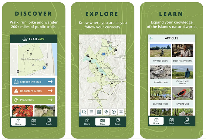
Sheriff’s Meadow Foundation launched the first TrailsMV mobile app, a free interactive guide to the Vineyard’s 220 miles of public trails in 2018. Well-received among walkers, birders, bikers, trail runners, and others, its popularity grew even as our goals for the app outpaced its technology. This past summer we launched a brand new TrailsMV with a dynamic redesign, using the latest in ArcGIS geospatial mapping technology.
The app features easy-to-read trail maps and descriptions for each property, shows your real-time location using GPS satellite technology (no WiFi or cell service needed), and highlights more than 100 conservation properties that are open to the public.
TrailsMV’s new features include:
- A guide with basic instructions on using the app, with Spanish and Brazilian Portuguese translations.
- A resources section with safety tips and helpful links, including the Vineyard Transit Authority’s bus routes.
- An events listing featuring nature-related activities open to the public. More articles about natural history and the outdoors. An expanded offering of excursions, including the new Aquinnah Headlands walk.
Coming soon:
- Filters to sort properties according to use (and restrictions), such as dogs, hunt- ing, accessibility, horses, family-friendly, bikes, and scenic views.
- Trail segment lengths to better gauge distance.
- A user profile page to save favorite trails, properties, routes, photos, etc.
- An excursion list of accessible properties and trails for people with mobility limitations.
- Individual trail descriptions.
Also in the works:
- Route planning and tracking, so you can monitor and save your progress.
- Enhanced data analytics, so conservation planners can better understand how, when, and where people are using the app to explore the Island’s protected lands and trails.
The new TrailsMV mobile app is made possible through the generous financial support and collaboration of individual donors, the Island’s conservation organizations, the Martha’s Vineyard Commission, the six Vineyard towns, and volunteer photographers. We are grateful to Cape Cod 5, Edey Foundation, Farm Neck Foundation, Martha’s Vineyard Bank Charitable Foundation, and Martha’s Vineyard Community Foundation, for helping underwrite the first phase of the new TrailsMV. The re-envisioned, updated TrailsMV app, developed in partnership with the Martha’s Vineyard Commission and Blue Raster, is a multi-phase project, with additional features rolling out in the months to come.
If you have suggestions or would like to help test the new app, contact trailsmv@sheriffsmeadow.org. We’d love your input!
Note: Download the new TrailsMV mobile app for your phone at the App Store and Google Play. We recommend deleting the old app to avoid confusion, as it is no longer being updated.